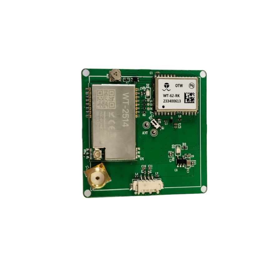
Field surveying teams often operate in remote areas lacking cellular network coverage. Furthermore, standard GNSS hardware fails to deliver accurate coordinates without network correction feeds. Today, adopting an advanced RTK receiver keeps high-precision mapping alive across off-grid environments. Consequently, survey engineers maintain strict lead-free compliance standards while capturing millimeter-accurate spatial data continuously.
Our integrated positioning solution breaks traditional cellular correction dependencies effortlessly. Therefore, field crews replace bulky external modems with a compact, all-in-one hardware architecture. Specifically, our board combines dual-frequency GNSS engines with long-range radio transmission modules. Explore our product-category for advanced off-grid positioning modules and development boards.
In addition, onboard multi-constellation algorithms deliver rapid fixed-solution convergence times. Consequently, autonomous platforms and handheld terminals compute centimeter-level coordinates in dense forests. Furthermore, low-power system architecture ensures extended battery autonomy during demanding remote field missions.
Commercial Pain Points: Resolving 4 Off-Grid Surveying Challenges
Remote field operations encounter distinct connectivity and environmental limits with traditional GNSS receivers. Below, we examine four primary positioning challenges and our technical solutions.
Complete Cellular Network Blackouts in Remote Terrains
Traditional RTK systems rely heavily on cellular CORS networks for differential corrections. Specifically, deep valleys, mountainous forests, and offshore sites lack reliable cellular coverage. Therefore, remote mapping projects require autonomous point-to-point correction links. Consequently, deploying a LoRa integrated RTK module guarantees continuous differential data delivery without cellular towers.
Example: Power line inspection drones operate deep within wilderness corridors miles away from urban infrastructure. Traditional network RTK rovers lose fix status immediately when cellular signals drop out. In contrast, local base stations stream corrections over integrated LoRa radio links directly to airborne receivers. Thus, autonomous mapping missions maintain fixed millimeter precision throughout long flight paths.
In addition, long-range radio protocol eliminates expensive monthly cellular data subscriptions. Furthermore, private radio links secure positioning data streams against public network interruptions. As a result, field teams operate reliably anywhere on earth.
High Power Consumption Draining Portable Terminal Batteries
Legacy RTK receivers require multiple power-hungry external modems and separate processing units. Specifically, heavy thermal dissipation drains battery packs rapidly during all-day field surveys. Therefore, portable GIS collectors require highly integrated, energy-efficient positioning hardware. Consequently, choosing an off-grid RTK positioning receiver extends operational field time significantly.
Example: Handheld GIS mappers conduct forestry inventory surveys across vast timber reserves for ten hours daily. Carrying heavy external battery packs increases operator fatigue and slows survey productivity. In contrast, our low-power architecture minimizes energy draw while maintaining full dual-frequency tracking.
Furthermore, fast cold-start TTFF reduces active processing time between survey points. Consequently, field terminals conserve battery reserves without sacrificing position update rates. Thus, survey crews complete full-day site visits on a single internal charge.
Signal Multipath and Loss of Fix Under Dense Canopy
Standard single-frequency GNSS receivers suffer severe multipath errors beneath dense tree foliage. Specifically, reflected satellite signals degrade positioning accuracy from centimeters down to several meters. Therefore, complex environmental surveying demands multi-constellation dual-frequency tracking. Consequently, deploying a GNSS RTK module maintains rock-solid fixed solutions under challenging cover.
Example: Environmental monitoring teams track subtle hillside soil displacements inside dense rainforest reserves. Single-frequency receivers fail to resolve integer ambiguities due to persistent canopy blockage. Check our technical-guide for detailed multi-frequency performance metrics.
In contrast, simultaneous tracking across BDS, GPS, GAL, and GLONASS signals provides superior signal redundancy. Furthermore, built-in RTK algorithms filter out severe multipath reflections automatically. Thus, monitoring stations track sub-centimeter ground movements reliably over long deployment periods.
Excessive Hardware Weight Burdening Lightweight UAV Platforms
Bulky, multi-component RTK assemblies add unnecessary payload weight to commercial survey drones. Specifically, excess weight reduces total flight endurance and limits mission coverage areas. However, integrated single-board solutions combine GNSS tracking, RF processing, and radio transmission seamlessly.
Example: Agricultural mapping drones require high-precision positioning to guide autonomous crop spraying systems. Hanging separate radio modems and antennas off lightweight airframes degrades flight stability. In contrast, our ultra-compact module integrates GNSS, radio, and antenna interfaces onto a tiny footprint.
Moreover, lightweight hardware integration preserves precious drone battery capacity for extended airtime. Consequently, aerial operators cover larger hectarage per flight battery cycle. Thus, commercial drone fleets increase daily operational efficiency effortlessly.
Technical Solutions: Advanced Architecture of WT-43-RK-LORA
Superior hardware engineering ensures uninterrupted positioning across demanding off-grid commercial applications. Furthermore, integrated long-range radio technology delivers reliable point-to-point correction coverage without external infrastructure.
Multi-Constellation Dual-Frequency Engine and Onboard LoRa
Engineers integrated a high-performance multi-system dual-frequency engine within the WT-43-RK-LORA module architecture. Specifically, the receiver tracks BDS (B1I/B2a/B1C), GPS (L1C/A/L5), GAL (E1/E5a), and GLONASS (L1) simultaneously. Furthermore, an integrated LoRa data module communicates directly with local base stations without external modems. Consequently, users achieve stable centimeter level positioning across isolated survey sectors.
In addition, the LoRa radio link achieves transmission distances of 1-2 km in urban environments. Furthermore, the signal reaches up to 5 km across open rural areas. Therefore, field crews establish private local base stations that cover expansive project sites easily.
Embedded Dual-Frequency Algorithms and High-Speed Motion Tracking
The module incorporates proprietary dual-frequency RTK algorithms directly on the onboard processor. Specifically, fast ambiguity resolution engines deliver rapid fixed solutions after temporary signal blockages. Furthermore, high update rates support precision positioning for high-speed UAVs and intelligent driving systems. Learn more in our /product-category hardware integration documentation.
Moreover, low-power electronic design minimizes system heat output during continuous operation. Thus, sealed outdoor monitoring enclosures operate safely across hot climate conditions. Consequently, hardware longevity and positioning stability remain uncompromised over years of field deployment.
Product Parameter & Specification Overview
Review key technical parameters and operational capabilities for the WT-43-RK-LORA module.
| Parameter / Specification | Standard GNSS Module | WT-43-RK-LORA RTK Module | Application & Operational Context |
| Positioning Accuracy | Meter-Level (1.5m – 2.5m) | Centimeter-Level Precision | High-Precision Mapping & GIS |
| Constellation Support | Single/Dual System | Quad-System Dual-Frequency | BDS, GPS, GAL, GLONASS |
| Off-Grid Radio Link | None (Requires External Cellular) | Integrated LoRa Data Module | Direct Base Station Communication |
| LoRa Range Coverage | N/A | 1-2 km (Urban) / Up to 5 km (Open) | No Cellular Signal Coverage Needed |
| RTK Engine Architecture | External Processor Required | Built-in Dual-Frequency Algorithm | Fast Fixed Solution Convergence |
| Power & Speed Profile | Standard Draw / Slow Fixed | Low Power / Fast Positioning | UAV, IoT, & High-Speed Motion |
Versatile Applications in Off-Grid Commercial Fields
Modern autonomous and industrial applications require robust positioning hardware that functions reliably everywhere. Furthermore, flexible integration capabilities suit diverse commercial and scientific field platforms.
For instance, power companies deploy the module for automated utility pole positioning and displacement monitoring. Specifically, sensors monitor subtle tower movements in remote mountain ranges without local cellular service. Consequently, maintenance centers detect structural shifts early to prevent catastrophic grid failures. Explore options in our technical-guide system integration section.
Additionally, smart agriculture manufacturers integrate the module into autonomous tractor steering systems. Operators run high-precision planting and tilling patterns across expansive rural farmlands seamlessly. Thus, farm managers optimize seed distribution and reduce operational overlap costs. Therefore, the WT-43-RK-LORA successfully merges off-grid radio range, dual-frequency precision, and ultimate operational reliability.