ทีมสำรวจภาคสนามมักปฏิบัติงานในพื้นที่ห่างไกลซึ่งขาดความครอบคลุมของเครือข่ายโทรศัพท์เคลื่อนที่. นอกจากนี้, ฮาร์ดแวร์ GNSS มาตรฐานไม่สามารถส่งพิกัดที่แม่นยำโดยไม่มีฟีดการแก้ไขเครือข่าย. วันนี้, การนำขั้นสูง เครื่องรับ RTK ช่วยให้การทำแผนที่ที่มีความแม่นยำสูงยังคงอยู่ในสภาพแวดล้อมนอกตาราง. เพราะเหตุนี้, วิศวกรสำรวจรักษามาตรฐานการปฏิบัติตามข้อกำหนดไร้สารตะกั่วที่เข้มงวด ขณะเดียวกันก็เก็บข้อมูลเชิงพื้นที่ที่มีความแม่นยำระดับมิลลิเมตรได้อย่างต่อเนื่อง.
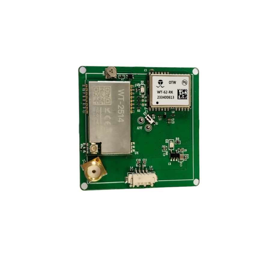
โซลูชันการกำหนดตำแหน่งแบบรวมของเราทำลายการพึ่งพาการแก้ไขเซลลูลาร์แบบเดิมๆ ได้อย่างง่ายดาย. ดังนั้น, ทีมงานภาคสนามเปลี่ยนโมเด็มภายนอกขนาดใหญ่ให้มีขนาดกระทัดรัด, สถาปัตยกรรมฮาร์ดแวร์ออลอินวัน. โดยเฉพาะ, บอร์ดของเราผสมผสานเครื่องยนต์ GNSS ความถี่คู่เข้ากับโมดูลส่งสัญญาณวิทยุระยะไกล. สำรวจของเรา หมวดหมู่สินค้า สำหรับโมดูลการกำหนดตำแหน่งนอกกริดและบอร์ดพัฒนาขั้นสูง.
นอกจากนี้, อัลกอริธึมหลายกลุ่มดาวในตัวให้เวลาการบรรจบกันของโซลูชันคงที่อย่างรวดเร็ว. เพราะเหตุนี้, แพลตฟอร์มอัตโนมัติและเทอร์มินัลมือถือจะคำนวณพิกัดระดับเซนติเมตรในป่าทึบ. นอกจากนี้, สถาปัตยกรรมระบบพลังงานต่ำช่วยให้มั่นใจได้ถึงความเป็นอิสระของแบตเตอรี่ในระหว่างภารกิจภาคสนามระยะไกลที่มีความต้องการสูง.
คะแนนความเจ็บปวดเชิงพาณิชย์: กำลังแก้ไข 4 ความท้าทายในการสำรวจนอกตาราง
การปฏิบัติงานภาคสนามระยะไกลเผชิญกับการเชื่อมต่อที่แตกต่างและข้อจำกัดด้านสิ่งแวดล้อมด้วยตัวรับ GNSS แบบเดิม. ด้านล่าง, เราตรวจสอบความท้าทายในการวางตำแหน่งหลักสี่ประการและวิธีแก้ปัญหาทางเทคนิคของเรา.
การปิดระบบเครือข่ายโทรศัพท์เคลื่อนที่อย่างสมบูรณ์ในพื้นที่ห่างไกล
ระบบ RTK แบบดั้งเดิมอาศัยเครือข่าย CORS แบบเซลลูลาร์เป็นอย่างมากในการแก้ไขส่วนต่าง. โดยเฉพาะ, หุบเขาลึก, ป่าภูเขา, และไซต์งานนอกชายฝั่งยังขาดความครอบคลุมสัญญาณโทรศัพท์เคลื่อนที่ที่เชื่อถือได้. ดังนั้น, โครงการการทำแผนที่ระยะไกลจำเป็นต้องมีลิงก์การแก้ไขแบบจุดต่อจุดแบบอัตโนมัติ. เพราะเหตุนี้, การปรับใช้ โมดูล RTK แบบบูรณาการ LoRa รับประกันการส่งข้อมูลส่วนต่างอย่างต่อเนื่องโดยไม่มีเสาสัญญาณเซลลูล่าร์.
ตัวอย่าง: โดรนตรวจสอบสายไฟทำงานลึกภายในทางเดินในป่าซึ่งห่างจากโครงสร้างพื้นฐานในเมืองหลายไมล์. โรเวอร์ RTK บนเครือข่ายแบบเดิมจะสูญเสียสถานะการแก้ไขทันทีเมื่อสัญญาณมือถือหลุด. ในทางตรงกันข้าม, สถานีฐานท้องถิ่นจะสตรีมการแก้ไขผ่านลิงก์วิทยุ LoRa ในตัวไปยังเครื่องรับทางอากาศโดยตรง. ดังนั้น, ภารกิจการทำแผนที่อัตโนมัติจะรักษาความแม่นยำของมิลลิเมตรคงที่ตลอดเส้นทางบินระยะไกล.
นอกจากนี้, โปรโตคอลวิทยุระยะไกลช่วยลดการสมัครสมาชิกข้อมูลมือถือรายเดือนที่มีราคาแพง. นอกจากนี้, วิทยุส่วนตัวจะเชื่อมโยงสตรีมข้อมูลตำแหน่งที่ปลอดภัยจากการหยุดชะงักของเครือข่ายสาธารณะ. ส่งผลให้, ทีมงานภาคสนามดำเนินงานได้อย่างน่าเชื่อถือทุกที่บนโลก.
แบตเตอรี่เทอร์มินัลแบบพกพาที่สิ้นเปลืองพลังงานสูง
เครื่องรับ RTK รุ่นเก่าต้องการโมเด็มภายนอกที่กินไฟหลายตัวและหน่วยประมวลผลแยกกัน. โดยเฉพาะ, การกระจายความร้อนจำนวนมากจะทำให้แบตเตอรี่หมดอย่างรวดเร็วในระหว่างการสำรวจภาคสนามตลอดทั้งวัน. ดังนั้น, เครื่องรวบรวม GIS แบบพกพาจำเป็นต้องมีการผสานรวมในระดับสูง, ฮาร์ดแวร์ระบุตำแหน่งที่ประหยัดพลังงาน. เพราะเหตุนี้, เลือกอัน ตัวรับสัญญาณตำแหน่ง RTK นอกตาราง ขยายเวลาการปฏิบัติงานภาคสนามได้อย่างมาก.
ตัวอย่าง: ผู้ทำแผนที่ GIS แบบมือถือดำเนินการสำรวจสินค้าคงคลังด้านป่าไม้ในพื้นที่สงวนไม้อันกว้างใหญ่เป็นเวลาสิบชั่วโมงต่อวัน. การพกพาชุดแบตเตอรี่ภายนอกที่มีน้ำหนักมากจะเพิ่มความเมื่อยล้าของผู้ปฏิบัติงานและทำให้ประสิทธิภาพในการสำรวจช้าลง. ในทางตรงกันข้าม, สถาปัตยกรรมที่ใช้พลังงานต่ำของเราช่วยลดการใช้พลังงานในขณะที่ยังคงการติดตามความถี่คู่เต็มรูปแบบ.
นอกจากนี้, TTFF เริ่มต้นเย็นอย่างรวดเร็วช่วยลดเวลาการประมวลผลที่ใช้งานระหว่างจุดสำรวจ. เพราะเหตุนี้, เทอร์มินัลภาคสนามช่วยประหยัดแบตเตอรี่สำรองโดยไม่ทำให้อัตราการอัพเดตตำแหน่งลดลง. ดังนั้น, ทีมงานสำรวจสามารถเยี่ยมชมสถานที่ได้เต็มวันโดยมีค่าใช้จ่ายภายในเพียงครั้งเดียว.
สัญญาณหลายเส้นทางและการสูญเสียการแก้ไขภายใต้หลังคาหนาแน่น
เครื่องรับ GNSS ความถี่เดียวมาตรฐานประสบปัญหาข้อผิดพลาดหลายเส้นทางอย่างรุนแรงใต้ใบไม้ที่หนาแน่น. โดยเฉพาะ, สัญญาณดาวเทียมที่สะท้อนจะลดความแม่นยำของตำแหน่งจากเซนติเมตรลงไปหลายเมตร. ดังนั้น, การสำรวจสิ่งแวดล้อมที่ซับซ้อนจำเป็นต้องมีการติดตามความถี่คู่แบบหลายกลุ่มดาว. เพราะเหตุนี้, การปรับใช้ โมดูล GNSS RTK คงไว้ซึ่งแนวทางแก้ไขที่มั่นคงภายใต้การปกปิดที่ท้าทาย.
ตัวอย่าง: ทีมติดตามด้านสิ่งแวดล้อมติดตามการเคลื่อนตัวของดินบริเวณไหล่เขาภายในเขตป่าฝนอันหนาแน่น. เครื่องรับความถี่เดียวไม่สามารถแก้ไขความคลุมเครือของจำนวนเต็มเนื่องจากการอุดตันของหลังคาอย่างต่อเนื่อง. ตรวจสอบของเรา คู่มือทางเทคนิค สำหรับการวัดประสิทธิภาพหลายความถี่โดยละเอียด.
ในทางตรงกันข้าม, การติดตาม BDS พร้อมกัน, จีพีเอส, แกลลอน, และสัญญาณ GLONASS ให้สัญญาณสำรองที่เหนือกว่า. นอกจากนี้, อัลกอริธึม RTK ในตัวจะกรองการสะท้อนหลายเส้นทางที่รุนแรงโดยอัตโนมัติ. ดังนั้น, สถานีตรวจสอบติดตามความเคลื่อนไหวของภาคพื้นดินที่มีขนาดต่ำกว่าเซนติเมตรได้อย่างน่าเชื่อถือตลอดระยะเวลาการใช้งานที่ยาวนาน.
ฮาร์ดแวร์ที่มีน้ำหนักมากเกินไปเป็นภาระให้กับแพลตฟอร์ม UAV น้ำหนักเบา
เทอะทะ, ชุด RTK ที่มีองค์ประกอบหลายองค์ประกอบเพิ่มน้ำหนักบรรทุกที่ไม่จำเป็นให้กับโดรนสำรวจเชิงพาณิชย์. โดยเฉพาะ, น้ำหนักที่มากเกินไปจะช่วยลดความทนทานในการบินโดยรวมและจำกัดพื้นที่ครอบคลุมภารกิจ. อย่างไรก็ตาม, โซลูชันบอร์ดเดี่ยวแบบรวมรวมการติดตาม GNSS, การประมวลผลคลื่นความถี่วิทยุ, และส่งสัญญาณวิทยุได้อย่างลงตัว.
ตัวอย่าง: โดรนทำแผนที่การเกษตรต้องการการวางตำแหน่งที่มีความแม่นยำสูงเพื่อเป็นแนวทางให้กับระบบฉีดพ่นพืชผลอัตโนมัติ. การแขวนโมเด็มวิทยุและเสาอากาศแยกกันออกจากโครงเครื่องบินน้ำหนักเบาจะลดเสถียรภาพการบิน. ในทางตรงกันข้าม, โมดูลขนาดกะทัดรัดเป็นพิเศษของเราผสานรวม GNSS, วิทยุ, และอินเทอร์เฟซเสาอากาศบนพื้นที่ขนาดเล็ก.
นอกจากนี้, การรวมฮาร์ดแวร์น้ำหนักเบาช่วยรักษาความจุของแบตเตอรี่โดรนอันมีค่าเพื่อยืดเวลาออกอากาศ. เพราะเหตุนี้, ผู้ควบคุมทางอากาศครอบคลุมพื้นที่ขนาดใหญ่กว่าเฮกตาร์ต่อวงจรแบตเตอรี่เที่ยวบิน. ดังนั้น, กลุ่มโดรนเชิงพาณิชย์เพิ่มประสิทธิภาพการดำเนินงานรายวันได้อย่างง่ายดาย.
โซลูชั่นทางเทคนิค: สถาปัตยกรรมขั้นสูงของ WT-43-RK-LORA
วิศวกรรมฮาร์ดแวร์ที่เหนือกว่าช่วยให้มั่นใจได้ถึงการวางตำแหน่งอย่างต่อเนื่องในแอปพลิเคชันเชิงพาณิชย์นอกเครือข่ายที่มีความต้องการสูง. นอกจากนี้, เทคโนโลยีวิทยุระยะไกลแบบบูรณาการมอบความครอบคลุมการแก้ไขแบบจุดต่อจุดที่เชื่อถือได้โดยไม่มีโครงสร้างพื้นฐานภายนอก.
เอ็นจิ้นความถี่คู่หลายกลุ่มดาวและ LoRa ออนบอร์ด
วิศวกรได้ผสานรวมกลไกความถี่คู่หลายระบบประสิทธิภาพสูงภายในสถาปัตยกรรมโมดูล WT-43-RK-LORA. โดยเฉพาะ, เครื่องรับจะติดตาม BDS (B1I/B2a/B1C), จีพีเอส (L1C/เอ/L5), แกลลอน (E1/E5a), และโกลนาส (L1) พร้อมกัน. นอกจากนี้, โมดูลข้อมูล LoRa ในตัวจะสื่อสารโดยตรงกับสถานีฐานในพื้นที่โดยไม่ต้องใช้โมเด็มภายนอก. เพราะเหตุนี้, ผู้ใช้บรรลุความมั่นคง ตำแหน่งระดับเซนติเมตร ทั่วทั้งภาคการสำรวจที่แยกจากกัน.
นอกจากนี้, ลิงค์วิทยุ LoRa มีระยะการส่งสัญญาณที่ 1-2 กม. ในสภาพแวดล้อมในเมือง. นอกจากนี้, สัญญาณไปถึง 5 กม. ในพื้นที่ชนบทที่เปิดโล่ง. ดังนั้น, ทีมงานภาคสนามจะจัดตั้งสถานีฐานส่วนตัวในพื้นที่ที่ครอบคลุมพื้นที่โครงการที่กว้างขวางได้อย่างง่ายดาย.
อัลกอริธึมความถี่คู่แบบฝังและการติดตามการเคลื่อนไหวความเร็วสูง
โมดูลนี้รวมอัลกอริธึม RTK ความถี่คู่ที่เป็นกรรมสิทธิ์โดยตรงบนโปรเซสเซอร์ออนบอร์ด. โดยเฉพาะ, เอ็นจิ้นการแก้ไขความกำกวมที่รวดเร็วมอบวิธีแก้ปัญหาที่รวดเร็วหลังจากการปิดกั้นสัญญาณชั่วคราว. นอกจากนี้, อัตราการอัปเดตสูงรองรับการวางตำแหน่งที่แม่นยำสำหรับ UAV ความเร็วสูงและระบบการขับขี่อัจฉริยะ. เรียนรู้เพิ่มเติมในของเรา /product-category เอกสารประกอบการรวมฮาร์ดแวร์.
นอกจากนี้, การออกแบบอิเล็กทรอนิกส์พลังงานต่ำช่วยลดความร้อนของระบบระหว่างการทำงานต่อเนื่อง. ดังนั้น, ตู้ตรวจสอบกลางแจ้งแบบปิดผนึกทำงานอย่างปลอดภัยในสภาพอากาศร้อน. เพราะเหตุนี้, อายุการใช้งานของฮาร์ดแวร์และความเสถียรของตำแหน่งยังคงไม่ลดลงในช่วงหลายปีของการใช้งานภาคสนาม.
พารามิเตอร์ผลิตภัณฑ์ & ภาพรวมข้อมูลจำเพาะ
ตรวจสอบพารามิเตอร์ทางเทคนิคที่สำคัญและความสามารถในการปฏิบัติงานสำหรับโมดูล WT-43-RK-LORA.
| พารามิเตอร์ / ข้อมูลจำเพาะ | โมดูล GNSS มาตรฐาน | WT-43-RK-LORA โมดูล RTK | แอปพลิเคชัน & บริบทการดำเนินงาน |
| ความแม่นยำของตำแหน่ง | ระดับมิเตอร์ (1.5ม. – 2.5ม.) | ความแม่นยำระดับเซนติเมตร | การทำแผนที่ที่มีความแม่นยำสูง & สารสนเทศภูมิศาสตร์ |
| การสนับสนุนกลุ่มดาว | ระบบเดี่ยว/คู่ | ระบบ Quad-System ความถี่คู่ | BDS, จีพีเอส, แกลลอน, กลอส |
| ลิงค์วิทยุนอกกริด | ไม่มี (ต้องใช้เซลลูล่าร์ภายนอก) | โมดูลข้อมูล LoRa ในตัว | การสื่อสารสถานีฐานโดยตรง |
| ความคุ้มครองช่วง LoRa | ไม่มี | 1-2 กม (ในเมือง) / ขึ้นไป 5 กม (เปิด) | ไม่จำเป็นต้องครอบคลุมสัญญาณมือถือ |
| สถาปัตยกรรมเครื่องยนต์ RTK | ต้องใช้โปรเซสเซอร์ภายนอก | อัลกอริธึมความถี่คู่ในตัว | การบรรจบกันของโซลูชันคงที่อย่างรวดเร็ว |
| พลัง & โปรไฟล์ความเร็ว | การจับสลากมาตรฐาน / แก้ไขช้า | พลังงานต่ำ / การวางตำแหน่งที่รวดเร็ว | UAV, ไอโอที, & การเคลื่อนไหวความเร็วสูง |
การใช้งานที่หลากหลายในสาขาเชิงพาณิชย์แบบ Off-Grid
แอปพลิเคชันอัตโนมัติและอุตสาหกรรมสมัยใหม่ต้องการฮาร์ดแวร์กำหนดตำแหน่งที่แข็งแกร่งซึ่งทำงานได้อย่างน่าเชื่อถือทุกที่. นอกจากนี้, ความสามารถในการบูรณาการที่ยืดหยุ่นเหมาะกับแพลตฟอร์มภาคสนามเชิงพาณิชย์และวิทยาศาสตร์ที่หลากหลาย.
เช่น, บริษัทผลิตไฟฟ้าใช้โมดูลนี้เพื่อกำหนดตำแหน่งเสาไฟฟ้าอัตโนมัติและติดตามตรวจสอบการเคลื่อนที่. โดยเฉพาะ, เซ็นเซอร์จะติดตามการเคลื่อนไหวของหอคอยเล็กๆ น้อยๆ ในเทือกเขาห่างไกลโดยไม่มีบริการโทรศัพท์เคลื่อนที่ในพื้นที่. เพราะเหตุนี้, ศูนย์บำรุงรักษาจะตรวจจับการเปลี่ยนแปลงของโครงสร้างตั้งแต่เนิ่นๆ เพื่อป้องกันความล้มเหลวของกริดที่ร้ายแรง. สำรวจตัวเลือกต่างๆ ของเรา คู่มือทางเทคนิค ส่วนการรวมระบบ.
นอกจากนี้, ผู้ผลิตการเกษตรอัจฉริยะได้รวมโมดูลเข้ากับระบบบังคับเลี้ยวของรถแทรกเตอร์แบบอัตโนมัติ. ผู้ปฏิบัติงานใช้รูปแบบการปลูกและการไถพรวนที่มีความแม่นยำสูงในพื้นที่เกษตรกรรมในชนบทที่กว้างขวางได้อย่างราบรื่น. ดังนั้น, ผู้จัดการฟาร์มเพิ่มประสิทธิภาพการกระจายเมล็ดพันธุ์และลดต้นทุนการทับซ้อนในการปฏิบัติงาน. ดังนั้น, WT-43-RK-LORA ผสานช่วงวิทยุนอกกริดได้สำเร็จ, ความแม่นยำความถี่คู่, และความน่าเชื่อถือในการปฏิบัติงานขั้นสูงสุด.