เกษตรกรเชิงพาณิชย์ยุคใหม่ต้องสร้างสมดุลระหว่างต้นทุนค่าโสหุ้ยในการดำเนินงานที่เพิ่มขึ้นกับความต้องการในการอนุรักษ์ดินที่สำคัญในแต่ละวัน. เพราะเหตุนี้, maximizing seasonal yields requires smarter field allocation strategies across every single acre. Traditional, imprecise planting methods often cause uneven nutrient depletion throughout vast field grids.
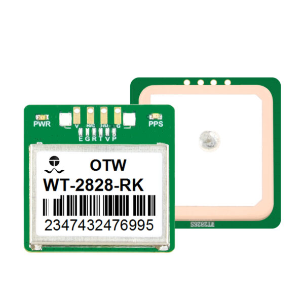
This management challenge explains why progressive growers now deploy a precision farming GPS receiver to handle complex field setups. Utilizing advanced satellite networks allows operators to track specific soil zones with absolute mathematical certainty.
This comprehensive guide details how smart geolocation tracking unlocks superior land use efficiency for diversified farms. We will analyze digital mapping workflows, row management tactics, and sustainable farming ROI parameters.
The Strategic Importance of Sustainable Crop Rotation
Crop rotation serves as a cornerstone of sustainable, high-yield agribusiness management. การปลูกพืชที่หยั่งรากลึกสลับกับพืชตรึงไนโตรเจนตามธรรมชาติจะช่วยฟื้นฟูโครงสร้างของดินที่เสื่อมสภาพเมื่อเวลาผ่านไป.
อย่างไรก็ตาม, การติดตามการเปลี่ยนแปลงขอบเขตตามฤดูกาลด้วยตนเองทำให้เกิดปัญหาด้านลอจิสติกส์อย่างมากสำหรับองค์กรเกษตรกรรมขนาดใหญ่. หากรถแทรกเตอร์ของคุณเลี้ยวออกไปเพียงไม่กี่นิ้ว, คุณรบกวนโซนสารอาหารที่วางแผนไว้อย่างระมัดระวัง.
[Year 1: Corn Feed] --> Heavy Nitrogen Consumptive Phase
[ปี 2: ถั่วเหลือง] –> ขั้นตอนการตรึงไนโตรเจนตามธรรมชาติ [ความแม่นยำที่จำเป็น] –> การจัดตำแหน่งนิ้วย่อยผ่านการล็อคดาวเทียม |
ดังนั้น, การรักษาการแบ่งแยกพื้นที่ที่เข้มงวดระหว่างตระกูลพืชผลที่แตกต่างกันถือเป็นสิ่งสำคัญอย่างยิ่ง. เครื่องรับ GPS สำหรับการเกษตรที่มีความแม่นยำสูง ป้องกันการทับซ้อนกันโดยไม่ตั้งใจระหว่างแถวพืชผลต่างๆ ได้อย่างง่ายดาย. ช่วยให้มั่นใจได้ว่าพืชเป้าหมายของคุณจะได้รับสภาพแวดล้อมทางดินที่ต้องการในการเจริญเติบโต.
บรรลุประสิทธิภาพการใช้ที่ดินสูงสุดด้วยการนำทางผ่านดาวเทียม
การเพิ่มพื้นที่ทุ่งให้สูงสุดทำให้ผู้ปลูกต้องกำจัดพื้นที่เพาะปลูกที่สูญเปล่าตามขอบสนามและหัวแหลม. การติดตามเครื่องจักรมาตรฐานมักจะสร้างช่องว่างที่ไม่จำเป็นหรือการทับซ้อนกันแบบ double-seed ในระหว่างกะการทำงานที่ยาวนาน.
แพลตฟอร์มนำทางด้วยดาวเทียมเพื่อการทำฟาร์มอัจฉริยะสมัยใหม่ช่วยแก้ปัญหาขยะเชิงพื้นที่นี้โดยทำให้รูปแบบการบังคับเลี้ยวที่ซับซ้อนเป็นอัตโนมัติ. ระบบจะนำทางเครื่องจักรหนักไปตามเส้นทางที่มีการปรับให้เหมาะสมที่สุด, ลดพื้นที่ที่ไม่ได้ปลูกให้เป็นศูนย์สัมบูรณ์.

นอกจากนี้, ความแม่นยำทางกายภาพขั้นสุดยอดนี้ช่วยลดค่าใช้จ่ายอินพุตตามฤดูกาลของคุณได้โดยตรง. รถแทรกเตอร์ประหยัดเชื้อเพลิงโดยดำเนินการแก้ไขน้อยลงเมื่อสิ้นสุดการผ่านการเพาะปลูกแต่ละครั้ง. รูปแบบการขับขี่ที่มีประสิทธิภาพนี้จะเพิ่มผลผลิตรวมในฟาร์มของคุณให้สูงสุด ในขณะเดียวกันก็ปกป้องชั้นดินชั้นบนที่เปราะบางจากการบดอัดอย่างหนัก.
การรวมซอฟต์แวร์ดิจิทัลเข้ากับฮาร์ดแวร์ภาคสนาม
Premium geolocation hardware delivers the best operational results when paired with intelligent data platforms. Modern agronomists utilize specialized crop rotation planning software to design multi-year field schedules.
Technicians upload these custom digital field maps directly into the tractor console via secure wireless links. The guidance system then reads the target coordinates to adjust seed distribution patterns instantly across changing topography.
-
Zone Isolation: Keeps chemical spray boundaries strictly separated from organic food plots.
-
Historical Tracking: Saves multiple years of yield history to analyze soil fertility trends accurately.
-
Dynamic Adjustments: Modifies planting density on the fly based on historical soil performance metrics.
-
Boundary Enforcement: ป้องกันไม่ให้ผู้ปฏิบัติงานข้ามเข้าไปในเขตระบายน้ำด้านสิ่งแวดล้อมที่ได้รับการคุ้มครองโดยไม่ได้ตั้งใจ.
เพิ่มประสิทธิภาพการตั้งค่าอุปกรณ์สำหรับสาขาที่หลากหลาย
การใช้อุปกรณ์เสริมการเชื่อมต่อคุณภาพสูงช่วยให้มั่นใจได้ว่าการสื่อสารข้อมูลระหว่างรถยนต์และเครือข่ายฐานจะมีเสถียรภาพ. เรียนรู้เพิ่มเติมเกี่ยวกับการกำหนดค่าระบบตัวรับส่งสัญญาณทางการเกษตรที่ทนทานเพื่อป้องกันข้อมูลตกระหว่างพายุฝุ่นที่รุนแรง.
4 ขั้นตอนในการทำแผนที่การหมุนครอบตัดอย่างแม่นยำโดยใช้ GPS
การใช้โปรโตคอลการหมุนที่ขับเคลื่อนด้วยดาวเทียมต้องใช้แนวทางทางเทคนิคที่เป็นระบบเพื่อให้แน่ใจว่าข้อมูลมีความสอดคล้องกันอย่างสมบูรณ์.
การเอาชนะความท้าทายด้านภูมิประเทศและความล่าช้าหลายเส้นทาง
ภูมิประเทศที่เป็นเนินเขาและแนวต้นไม้โดยรอบสามารถปิดกั้นสัญญาณดาวเทียมนำทางทั่วโลกมาตรฐานโดยไม่คาดคิด. เมื่อรถแทรกเตอร์ทำงานในหุบเขาลึก, สิ่งกีดขวางทางกายภาพจะเบี่ยงเบนคลื่นวิทยุที่เข้ามา, ทำให้เกิดความล่าช้าในการวางตำแหน่งชั่วคราว.
เครื่องรับระดับไฮเอนด์จะแก้ไขปัญหานี้โดยการใช้กลุ่มดาวดาวเทียมหลายดวงพร้อมกัน, เช่น จีพีเอส, กลอส, และกาลิเลโอ. การเข้าถึงดาวเทียมหลายสิบดวงพร้อมกันช่วยรักษาความแม่นยำระดับต่ำกว่านิ้วแม้อยู่ใต้หลังคาบางส่วน.
[Multiple Satellites] ---> Redundant Signals ---> Stable RTK Correction ---> Pure Precision |
นอกจากนี้, โมดูลชดเชยความเอียงภายในขั้นสูงจะปรับข้อมูลตำแหน่งเมื่อรถแทรกเตอร์พิงบนทางลาดชัน. การคำนวณอัตโนมัตินี้ช่วยให้มั่นใจได้ว่าการเจาะเมล็ดจะหยอดเมล็ดตามเส้นกึ่งกลางที่วางแผนไว้ทุกประการ. อ่านรายละเอียดจากผู้เชี่ยวชาญของเราเกี่ยวกับการปรับพารามิเตอร์การปรับเทียบพวงมาลัยอัตโนมัติเพื่อให้อุปกรณ์ของคุณทำงานตรง.
ประโยชน์ระยะยาวของการวางแผนการเกษตรที่ขับเคลื่อนด้วย GPS
การเปลี่ยนไปใช้การจัดการแถวแบบอัตโนมัติทำให้เกิดข้อได้เปรียบด้านพืชไร่อย่างมาก ซึ่งนอกเหนือไปจากความสะดวกในการบังคับเลี้ยวแบบธรรมดา.
อันดับแรก, การวางตำแหน่งสนามที่แม่นยำช่วยลดความจำเป็นในการไถพรวนแบบลึกในช่วงหลายฤดูกาล. เนื่องจากล้อแทรคเตอร์ของคุณวิ่งตามเส้นทางการติดตามที่เหมือนกันเสมอ, คุณจำกัดการบดอัดดินที่เป็นอันตรายให้อยู่ในเลนที่กำหนด. การปฏิบัติเช่นนี้ทำให้แปลงเมล็ดที่อยู่รอบๆ หลวม, มีรูพรุน, และเปิดรับการเจริญเติบโตของรากอย่างมาก.
ที่สอง, บันทึกการใช้งานที่แม่นยำช่วยให้คุณปฏิบัติตามมาตรฐานการรับรองด้านสิ่งแวดล้อมที่เข้มงวดได้อย่างง่ายดาย. คุณสามารถพิสูจน์ประวัติทางเคมีที่แน่นอนของคุณต่อหน่วยงานกำกับดูแลได้โดยใช้บันทึกดิจิทัลที่ได้รับการตรวจสอบแล้ว. ความโปร่งใสนี้ช่วยให้ธุรกิจการเกษตรของคุณสามารถเข้าถึงตลาดอาหารออร์แกนิกและยั่งยืนระดับพรีเมียมทั่วโลก.
เกษตรกรรมที่ขับเคลื่อนด้วยข้อมูลช่วยรักษาอนาคตของคุณ
เครื่องรับ GPS สำหรับการเกษตรที่มีความแม่นยำสามารถเพิ่มประสิทธิภาพการจัดการภาคสนามตามฤดูกาลของคุณได้อย่างแท้จริง? หลักฐานเชิงประจักษ์ชี้ไปที่ใช่ดังกึกก้อง.
โดยการใช้ การนำทางด้วยดาวเทียมที่มีความแม่นยำสูง, คุณกำจัดการทับซ้อนกันของแถวที่สิ้นเปลืองและเพิ่มพื้นที่ใช้งานทั้งหมดของคุณให้สูงสุด. การรวมฮาร์ดแวร์ทางกายภาพของคุณเข้ากับเครื่องมือการทำแผนที่ GIS ทางการเกษตรขั้นสูง ช่วยให้สามารถควบคุมสภาพดินเป็นเวลาหลายปีได้อย่างสมบูรณ์. อย่าปล่อยให้ผลผลิตภาคสนามของคุณเป็นเพียงการคาดเดาหรือวิธีการแบบแมนนวลที่ล้าสมัย. ลงทุนในระบบระบุตำแหน่งทางภูมิศาสตร์แบบมืออาชีพวันนี้เพื่อปกป้องทรัพย์สินในดินของคุณ, เพิ่มผลผลิตพืชผล, และเพิ่มรายได้ฟาร์มของคุณให้สูงสุด.