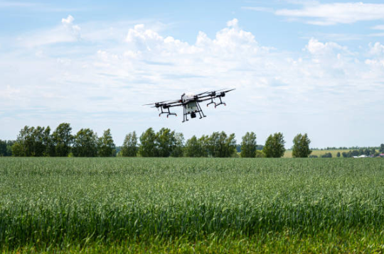
드론이 레크리에이션 도구에서 농업용 지능형 도구로 진화함에 따라, 매핑, 물류, 정확한 네비게이션이 성공의 기초가 됩니다. 엔지니어용, UAV 개발자, 그리고 자동화 스타트업, 드론 내비게이션에 적합한 GPS 모듈을 선택하는 것이 바로 날아다니는 프로토타입과 지능적이고 정확하게 작동하는 프로토타입의 차이입니다..
이 기사에서는 최신 GPS 모듈이 스마트 드론 프로토타입을 어떻게 향상시키는지 살펴봅니다., 개발 시간 단축, 강력한 성능을 보장합니다, 특히 다음과 같은 신뢰할 수 있는 제조업체와 파트너십을 맺을 때는 더욱 그렇습니다. 안제.
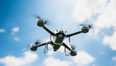
GPS 모듈이 스마트 드론 내비게이션의 핵심인 이유
드론 개발 초기 단계, 포지셔닝 시스템은 종종 전체 비행 제어 전략을 결정합니다.. 드론 내비게이션용 GPS 모듈로 실시간 위치 제공, 고도, 속도 데이터, 드론이 경로를 계획할 수 있도록 지원, 장애물을 피하다, 자율 임무를 수행하고.
주요 이점:
-
정확한 포지셔닝: GNSS 통합으로 서브미터 또는 센티미터 수준의 정확도.
-
안정적인 비행 조종: 바람이 불거나 간섭이 심한 지역에서도 부드러운 궤적 수정.
-
데이터 동기화: 센서와의 원활한 통합, IMU, 및 온보드 프로세서.
-
임무 유연성: 매핑부터 작물 모니터링까지 다양한 애플리케이션에 적용 가능.
귀하의 목표가 농업용 드론 개발인지 자율 검사 장치 개발인지 여부, 산업 등급 성능을 달성하려면 고품질 드론 GPS 시스템이 필수적입니다..

GPS 모듈이 드론 프로토타입 제작 속도를 높이는 방법
현대 드론 개발에는 효율성과 확장성이 필요합니다.. 고정밀 GPS 모듈은 탐색 정확도를 제공할 뿐만 아니라 테스트 및 통합을 단순화합니다..
1. 보다 빠른 설계 검증
산업용 등급 GPS 모듈을 사용하면 엔지니어는 설계 단계 초기에 실제 비행 테스트를 실행할 수 있습니다.. 신뢰할 수 있는 데이터 정확성, 여러 하드웨어 개정 없이 탐색 알고리즘을 검증할 수 있습니다..
2. UAV 시스템과의 손쉬운 통합
대부분의 전문 모듈은 이제 표준 비행 컨트롤러와의 플러그 앤 플레이 호환성을 지원합니다.. 이는 디버깅 주기가 단축되고 개발 비용이 절감됨을 의미합니다..
3. 실시간 성능 피드백
개발자는 비행 경로 편차를 분석할 수 있습니다., 숨어 있음, 그리고 즉시 포지셔닝 드리프트. 이 피드백은 펌웨어를 최적화하고 그 어느 때보다 빠르게 드론 움직임을 미세 조정하는 데 도움이 됩니다..
4. 현장 테스트의 가동 중지 시간 감소
거친 실외 조건에 맞게 설계된 모듈은 GPS 신호 손실을 방지합니다., 복잡한 지형에서도 지속적인 테스트 보장 - 자율 비행 모듈 개발에 중요.
스마트 드론 프로젝트에 적합한 GPS 모듈 선택
수많은 GNSS 및 GPS 솔루션 사용 가능, 올바른 모델을 선택하려면 애플리케이션 요구 사항을 신중하게 고려해야 합니다..
평가할 핵심 요소
-
포지셔닝 정확도: 매핑 또는 배달 드론용, RTK 지원 또는 다중 대역 모듈을 찾으세요..
-
업데이트 속도: 더 높은 새로고침 빈도 (10-20Hz) 보다 원활한 비행 제어 보장.
-
전력 효율성: 소형 또는 경량 UAV에 필수.
-
간섭 저항: 도시 또는 자기 환경에서 일관된 신호 보장.
-
통신 인터페이스: UART 지원, SPI, 또는 I²C가 설계 유연성을 향상시킵니다..
Anze는 고정밀 GNSS 호환성을 갖춘 맞춤형 GPS 모듈 솔루션을 제공합니다., UAV 전반에 걸쳐 신속한 통합을 위해 설계됨, AGV, 로봇 플랫폼.
바쁜 연휴 동안 Anze와 같은 신뢰할 수 있는 공급업체와 협력
연휴 기간 동안, 생산 수요는 최고조에 달하고 리드 타임은 단축됨. 신뢰할 수 있는 GPS 모듈 제조업체와의 협력을 통해 일관된 품질 보장, 빠른 배송, 및 기술 지원—대규모 프로젝트를 준비하는 개발팀에게 특히 중요합니다. 2025 발사하다.
안제를 선택하는 이유:
-
업계 전문성: GNSS 및 UAV 전자 분야에서 수십 년간의 경험.
-
신속한 프로토타이핑 지원: R에 대한 빠른 샘플 및 모듈 테스트&디.
-
글로벌물류: 성수기 수요 기간 동안 효율적인 배송.
-
OEM 유연성: 드론 플랫폼을 위한 맞춤형 모듈 구성.
선택 안제 개발 파트너란 고객이 요구하는 신뢰할 수 있는 공급망과 성능 안정성을 확보하는 것을 의미합니다..
스마트 드론 시스템에 GPS 모듈 적용
| 적용분야 | GPS 통합의 이점 |
|---|---|
| 농업용 드론 | 정확한 현장 매핑 및 자동 분사 경로 |
| 조사 & 매핑 | 고해상도 지형 데이터 수집 |
| 배달 드론 | 경로 최적화 및 정확한 착륙 |
| 자율주행차 | 도시 내비게이션을 위한 다중 센서 융합 |
| 재난 대응 UAV | 복잡한 환경에서도 안정적인 추적 |
As the smart city and UAV logistics markets expand, drones with enhanced navigation accuracy gain a competitive advantage.
Looking Ahead: The Future of GPS and Smart Drone Navigation
The next generation of GPS modules for drone navigation will integrate AI-based correction, real-time kinematics (RTK), and 5G connectivity. These upgrades will allow drones to fly smarter, adapt faster, and operate with human-like perception.
For innovators and manufacturers, now is the time to secure long-term partnerships with trusted suppliers to stay ahead of the curve.
결론
A reliable GPS module for drone navigation is not just a component—it’s the core of a successful drone prototype. 고성능 모듈을 선택하고 다음과 같은 경험이 풍부한 파트너와 협력함으로써 안제, 개발자는 혁신 주기를 가속화할 수 있습니다., 위치 정확도 향상, 바쁜 연휴 제조 시즌에 맞춰 글로벌 시장 확장을 준비합니다..
자주 묻는 질문 (FAQ)
1. 드론용 전문 GPS 모듈에서 어떤 정확도를 기대할 수 있나요??
다중 GNSS 및 RTK를 지원하는 고급 모듈은 센티미터 수준의 정밀도를 달성합니다., 매핑 및 산업용 드론에 이상적.
2. GPS 모듈을 기존 비행 컨트롤러에 어떻게 통합하나요??
대부분의 모듈은 표준 통신 인터페이스를 지원합니다. (UART/SPI/I²C). Anze는 원활한 통합을 위해 기술 문서 및 펌웨어 지원을 제공합니다..
3. 지금이 GPS 모듈 공급업체와 파트너십을 맺기에 가장 좋은 시기인 이유?
연휴 기간 동안, Anze와 같은 공급업체는 빠른 프로토타이핑 서비스를 제공합니다., 안정적인 재고, 특별 OEM 지원, 개발자가 엄격한 R을 충족하도록 지원&D 타임라인.