Coastal mapping demands extreme precision and reliability. Water surfaces reflect signals and create interference. As a GPS R&D expert, I see these challenges daily. Standard receivers often fail in these harsh environments. However, a stable signal G-Mouse changes the game. This compact device integrates an antenna and receiver into one unit. It provides robust data even in remote maritime areas. Today, we explore how this technology reshapes coastal surveying.
The Science Behind the Signal
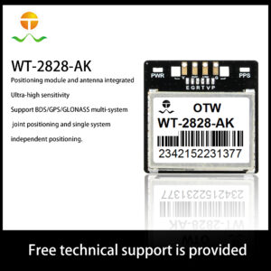
How does a G-Mouse maintain such a steady connection? The core lies in its multi-GNSS support. Most modern units track GPS, GLONASS, Galileo, and BeiDou simultaneously. This variety ensures that the device sees more satellites. Even if one signal is blocked, others remain active. Furthermore, advanced filtering algorithms reduce “multipath” errors caused by water. This creates a clean data stream for surveyors.
Internal Mechanics: How Built-in GPS Works
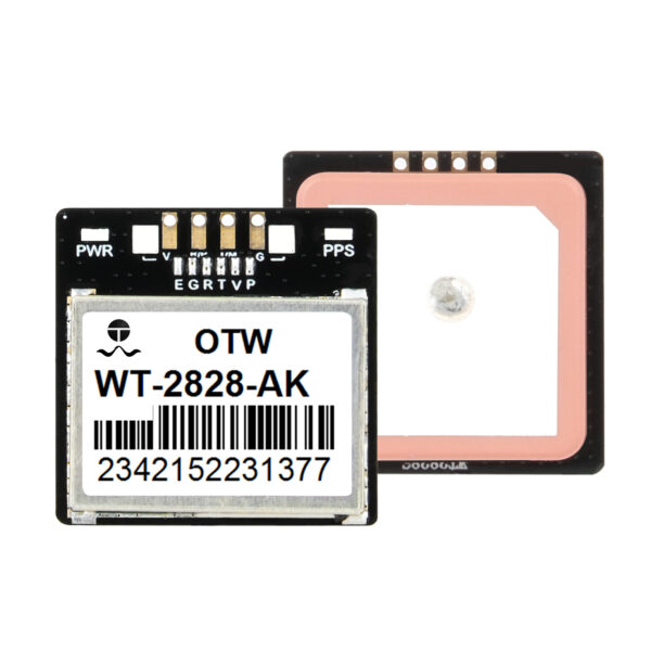
To appreciate the G-Mouse, we must look inside. It is a masterpiece of miniaturization and shielding.
1. Integrated Antenna Design
The G-Mouse features a high-gain ceramic patch antenna. We tune this antenna to specific frequencies. Its placement prevents interference from other electronic components. This design captures weak signals from the horizon easily.
2. Low Noise Amplifier (LNA)
Before the chip processes data, the LNA boosts it. It amplifies the satellite signal while ignoring background noise. This is critical when working near heavy port machinery. A stable signal G-Mouse relies on this clear input.
3. High-Speed Processing
The internal GNSS chip calculates position at high rates. Many units now offer 10Hz or 20Hz update speeds. This means the device updates its location 10 times per second. For a moving survey boat, this speed is essential.
Why Coastal Mapping Needs High-Precision G-Mouse Units
Coastal zones are dynamic and dangerous environments. Tide levels and sandbars shift constantly. Accurate mapping prevents ship groundings and protects ecosystems.
Overcoming Signal Reflection
Water acts like a mirror for radio waves. These reflections confuse standard GPS units. A professional stable signal G-Mouse uses “masking” technology. It ignores low-angle signals that are likely reflections. This ensures that only direct satellite data reaches the processor.
Durability in Salty Air
Saltwater is highly corrosive to electronics. Most G-Mouse receivers feature IP67 or IP68 waterproof ratings. The rugged housing protects the internal high-precision GNSS circuitry from failure. You can mount it outside without fearing the elements.
Ease of Integration
Coastal surveyors use various tablets and rugged laptops. A G-Mouse usually connects via USB or Serial ports. This “plug-and-play” nature saves time in the field. You do not need complex external power supplies or bulky antennas.
【Mapping the Great Barrier Reef】
Let’s look at a real-world application of this technology. A research team recently mapped shallow reef sections. They used a small autonomous surface vehicle (ASV).
Challenge:
The ASV moved constantly with the waves. Traditional GPS units lost lock during heavy rolls. The team needed a solution that stayed connected.
Solution:
They installed a stable signal G-Mouse on the highest point. The unit utilized its multi-constellation tracking capabilities. It maintained a sub-meter accuracy level throughout the day.
Result:
The team completed the survey 30% faster than planned. They did not have to re-map areas due to signal drops. This saved thousands of dollars in operational costs. It proved that reliable hardware is the foundation of good data.
Key Benefits of Using a G-Mouse for Marine Surveys
Why should you choose this specific form factor? The benefits extend beyond just “accuracy.”
-
Cost-Effectiveness: G-Mouse units provide professional results at a fraction of the cost.
-
Portability: You can move the device between different vessels easily.
-
Low Power Consumption: They draw very little power from the host device.
-
Rapid Cold Starts: High-quality chips find satellites in seconds, not minutes.
-
Consistent Performance: They maintain a lock even under light tree cover or near cliffs.
Future Trends: RTK and the G-Mouse
As an R&D expert, I look toward the future. We are now integrating Real-Time Kinematic (RTK) technology into G-Mouse designs. This will bring centimeter-level accuracy to the palm of your hand. Coastal mapping will become even more precise. We are also focusing on EMI shielding improvements to block 5G interference. The goal is always a cleaner, faster, and more reliable signal.
Setting the Standard for Coastal Data
Precision is not optional in maritime industries. It is a requirement for safety and efficiency. A stable signal G-Mouse offers the perfect balance of performance and price. It handles the unique challenges of the coastline with ease. By choosing high-quality GPS hardware, you protect your project’s integrity.
Investing in the right tools today saves time tomorrow. Whether you map reefs or monitor tide walls, reliability matters. Trust in the science of stable signals. Your data, and your vessel, depend on it. Ensure your next mission uses the best GNSS tech available. Let’s build a more accurately mapped world together.